Home » News » Competing in the OMM Elite Class 2017
in Navigation
People say its tough and this is true. Its extremely tough at the best of times but when you combine an Elite Course with the 50th commemorative year for the event and base it in the English Lake District then it becomes what might be known as a MONSTER!
Of the years I've taken part I have suffered, at what ever level I have been capable of, because in all honesty, its never going to feel easy when you are pushing yourself.
In 2012, the year I completed the Dragon's Back Race, I found I hit a wall on both day 1 and day 2 due to just being 'tired' still from the DBR in September. To be expected.
In 2014 I completed the OMM Elite with Chris Baynham-Hughes and we found the maps lacking, the course not the best and the distance was extremely long both days, but we finished a respectable 6th place.
In 2016 I ran with Ali Beavan and although we were going really well on the 1st day, Ali decided to drop one leg straight down a bottomless hole, damaging his right ankle, meaning we had to walk for the second half of the course for that day. We decided before we got to midway camp that we would not compete as Ali couldn't really run across the rough ground, but even though we walked for half of the 1st day, we still finished a respectable 14th place that day out of 33 starters.
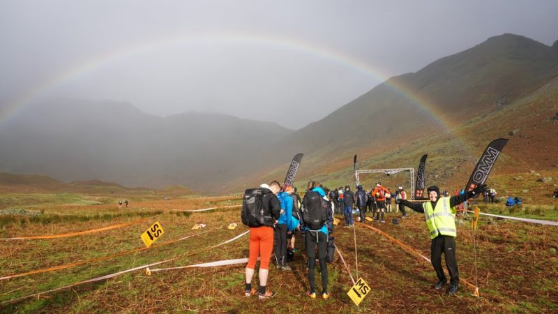
2017 was a MUST enter event. On home turf in the Lakes, based out of Langdale. How could you not?
The Elite Class is the original mountain marathon. Over both days combined it is likely that you will travel 85km and take in around 4000m of ascent and descent on top of that across the roughest mountain terrain the planner can find. Controls (orienteering kites) are placed so they are very technical in nature and require excellent navigational skills to find them. On top of this attack points may well be vague and they will require a combination of navigation skills, plus a excellent understanding of contour interpretation to guide you and your partner through the lumps and bumps of the terrain on the ground, understanding this terrain in how it is depicted on the map. This by far is the most important tool you need to have in your navigation skill box and making sure either one of you or both of you are 'in contact' with the map at all times is paramount lest you find yourselves in zero visibility and starting to feel like you are miss placed.
These skills need to be practiced and honed time and time again, as if for what ever reason you are rusty, then this will impact on your speed of travel across the terrain quite drastically.
The 50th commemorative event looked like it would be a real treat, with Joe Faulkner planning the 'Score Courses' and Graham Atkinson planing the 'Linear Courses'.
Planning courses and getting it right for all is a long and drawn out job and there is much riding on what you plan. Make it too easy and the top teams will complain, make it to hard and you risk a small finishing field and having lots of runners feeling upset that they didn't complete the weekends running.
This years weather combined with very long and tough courses gave slow completion times combined with a very small finishing field with over 75% of the Elites not finishing Day 1.
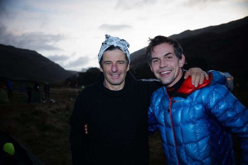
My partner: Just a little about my partner. Tim Laney is now 58, but he still runs amazingly well. I only wish to run like Tim at his age, he's still competing in 100 milers and loves them.
In his prime Tim ticked off the Bob Graham, Paddy Buckley and Charlie Ramsay rounds in excellent time, still holding a time in the top 10 for the BGR. He used to run with Mark McDermot and Mark Hartell if my memory is right and was at the top of his game for many years. For his age he still is. Tim has also completed over 30 OMM's, but isn't part of the 'club'. Tim is a very understated runner.
Day 1:
The day was forecast for some quite testing weather to blow in from the North West, with minimal visibility and very low cloud for most of the day. Continual drizzle/light rain and then turning more windy as the day progressed with the threat of heavier rain during the evening and night. The forecast was not wrong.
Combined with this the courses were planned very well offering very technical control placement and plenty of route choice to make the best of navigators think hard as to what the right route choice is for them and this for me is a key point. There is often 'one' best route, but not for every team, as you must remember that a 'planners route choice' is based not only on what might be perceived as the quickest line, but also the quickest line for the person choosing that route. My route choice will be based on mine and my partners strengths and weaknesses, how well we are performing on the terrain on the day, the weather conditions and of course how our mental state is at the time.
Running in the Elite Class gives you very little time to think when the the start box is punched, gone is the luxury of stopping for 5 minutes to work out what you think might be the best route through either the whole day or part of the day, now you must take the map and start moving directly you cross the start line and basically workout your route as you navigate around the course.
You have 1 minute to view the map before the race starts and in this minute both team members scrutinise the map to make the best assessment of route choice for the 1st few controls. Idea's are exchanged quickly and quietly, lest your competitors might learn something from you that you don't want them to know about!
Execution of the first few control sites is paramount for the rest of the day to go well. Cock up the first control or any of the first few and that can have drastic effects on the phycology of the rest of the race for one or both of the team.
If you feel you make the right choices and and hit the controls bang on, 1, 2, 3 etc, then the rest of the day is likely to go very well.
Control 1 came with 2 route choices, straight, steep and direct or faster running up a track, less ascent and contouring into it. We took the direct route... halfway up got me thinking faster track and less ascent might have been the better choice. We picked the control up without and fuss and set off to Control 2. This was in difficult terrain, but on the BGR line and knowing the area definitely helped here, we hit it again without consequence and set off to contour around the head of Wythburn Valley. Control 3 again was in quite a technical location, but I felt we could find it quickly as I had placed a control here as well in the 2011 Saunders Lakeland Mountain Marathon, the 1st MM I had the pleasure of planning.
Here we were passed by 2 teams and that is always a dangerous thing as it tends to put a rocket up your arse and you find yourself chasing them, but if they are moving a greater pace than you already then its likely they are running better as by this stage of the day you have already settled into 'your pace'. A slight error on a bearing put us 100m to the south of Control 4 and another team passed us. This time it was Jim Mann and Nick Barber and as I put on the afterburners to keep them in sight, Tim struggled to keep pace. The ground was rough and wet and I think this move by me definitely impacted us later in the day.
I should mention here that I have run most of the events I have competed in without the aid of an Altimeter, but on this occasion and for the last few my parters have had one to keep us on track.
Altimeters are excellent bits of technology. Some use the barometric pressure to ascertain the height you are at in the mountains, some use satellites and work the same as a GPS device does gaining the information from triangulating your height position. [Be careful not to confuse an Altimeter using GPS positioning with an actual GPS, as GPS's are not allowed in a race of this kind, as you can fix your location very easily and this is called 'Cheating'!] Remember that a barometric altimeter will need to be reset during your day from actual know heights like summits or other fixed features where you know the exact height, as when the pressure changes during the day and the weather blows through you will then find the reading you get on the device becomes in-accurate as the device uses the air-pressure to determine your height.
Control 5 looked simple enough, but beware the simple looking controls! With a long hill climb into descending CLAG meant it could be harder than it looked.
We over shot it, climbed too high, had no way then of knowing where it was and needed to re-gain our location and find an attack point. This takes time, this lost us time.
A quick synopsis of how navigation should work during an event like this is; Make your route choice (on the move in the case of running at the top end of any of the classes), instantly thumb your map to keep your location easy to find as you run, workout some collecting features to keep you on track and semi-located at all times, work out a catching feature so you don't make a monumental mistake by over shooting the control sight. Find an attack point if possible and as close as possible to your control sight, this will minimise the margin for error. Understand and be proficient in using hand-railing, aiming off and using formula's like Naismith's Rule whilst on the move and know your own speed of travel across rough ground. Use timing and pacing whilst on the move and break the leg down if its a long one, bouncing from feature to feature to minimise errors. Read the contours like your life depends on it. Keep in contact with the map at all times and discuss navigational choices with your partner throughout the event to make sure you are both in agreement or be able to find the best route for both of you.
Back to control 5.....
We over shot, we then needed to find a linear feature to regain our location exactly and then use it as a point of reference to now find this control. All this was done with a minimal amount of fuss and we picked up our control, but we had lost around 10 to 15 minutes in this process.
Control 6. Maybe we should have used the path to find the main path to Styhead Tarn from the blunt ridge of Glaramara but it looked like a slow route so we wove our way through technical ground to hit the path quicker, however with tiredness starting to kick in, a drop in body temperature and a slight sugar crash left me floundering somewhat with the map and when Tim and I hit the path we just 'assumed' we were on the right path and descended down it at speed. [Remember; To ASSUME makes an ASS of U and ME both!] Something wasn't quite right but the path was quick and we had made the cardinal error of not making a 'rough' bearing to check the track we were running on was actually heading in the right direction. Almost simultaneously both Tim and I realised we had made an error. I knew as we dropped out of the CLAG that the valley was wrong and Tim shouted out the height from his altimeter... we were 150 lower than were we should have been, we had descended somehow into the wrong valley. We had descended into the head of Seathwaite on the Grainy Gill side!!
We corrected our error by making a direct ascent up the side of Seathwaite Fell to gain the control. The descent off here was wet and slippery and the ground conditions were affecting my knee's. A long slog up Arrant Haw took us to Windy Gap, more clothing was needed and we both got cold... from now on we started to make errors more frequently and navigational choices became harder as our mental state went down hill, combined with not enough fuel being put in the tank (both of us were light on food) and the weather conditions worsened. From Control 7 to 8 was a major slog, but we hit the control sight efficiently and moods started to change with almost the last 'major' ascent behind us. The double drop into Wasdale felt cruel, but with it behind us we felt we were now on our way home, however we were both now fatigued.
Control 9 was a sheep fold on the side of Slight Side and it caused many teams a real problem, plenty of folk just not being able to find it. The attack point was vague, but we managed to hit it with the help of other teams being visible leaving the control sight. Up until this point I was staying up right ok, but had taken a few stumbles but now I hit the deck more times than I can ever remember in an event. Leaving the control I fell and smashed my compass on a rock saving myself. The onset of darkness came with quite a shock to me, but the thick CLAG made it feel dark early. Navigation errors were now made quite frequently and I kept slipping with my Inov8 X-Talon's just not being able to cope with the wet ground and me being majorly fatigued. We lost time again.
Its the second time I have put a head-torch on to finish an OMM, the last time was in 2005 on the last KIMM. Night time, heavy weather and fatigue made the final ascent and final control hard to find, with plenty of teams missing this control, but we hit it without too much consequence although Tim did decide to take a bath in the man eating bog nearby!
Dropping into Cockley Beck had me completely in a daze and I really hadn't a clue where we were actually descending to apart from the fact I knew we were going the right way and the Mid-Way Camp was imminent. We had finished the 1st day with 50 minute to spare before the courses were closed. We were the 10th to finish that day, but at least we had stuck it out and made it, as 75% of the rest of the field had either missed control sights or retired due to a multitude of reasons.
It was my hardest mountain day this year, feeling much harder than the Charlie Ramsay Round I completed with Damian Hall earlier this year in May. [This was also made on-sight]
The Mid-Way Camp was wet and windy. Quickly we located a semi-dry campsite and got the tent up. Getting dry clothes on in the tent, plus getting hot food in you stomach is a priority after a long day in the mountains.
With this done we got a quick sleep and then had some more food. My body was in pain after the exertion of the day and my knee's were hurting due to being bent to extreme angles from falling too many times so with pain killers administered we settled down for a good nights sleep in a sardine can of a Terra Nova Ultra 1.
The wind was strong at points during the night and I remember the tent flattening on our faces in the half-awake state induced by sleep, pain killers and tiredness from the day!
I should point out here that self-management skills and looking after your partner are key skills. Mess around in the midway, not managing to get food inside you quickly, leaving damp clothes on and generally just not being slick, neat and tidy will impact on your performance for day 2 for sure!
Day 2:
We woke to a great sunrise, pink hues giving us promise of a beautiful day ahead and indeed that is what were were in store for. Wall to wall sunshine, barely a cloud in the sky, which was of course perfect for me as I had broken my compass on Day 1.
Tim and I both took time to warm up tired muscles and joints and it became apparent to me that I had injured my knees from falling on Day 1. Ascending and moving across flattish terrain was fine, but descending was agony, but despite this we moved well and took some of the quicker times between the some of the controls. Navigation was easy, but route choices harder as descents were painful so we tried to find the least painful for me... but in the end I just had to accept that if we were to try to race then we just had to descend the steep slopes and me grit my teeth.
Day 2 was a pleasure to be out in, but still the course was long and hard and it seemed cruel to view the events centre and finish from the flanks of Cold Pike before descending over the back of it to traverse to Gerry Charnley's Cairn.
I think the knowledge to learn from Day 2 was that being able to pick a line and move quickly across the ground was the order of the day. Be strong in your conviction and then once the decision was made, just to move as fast as possible, moving efficiently at the same time.
The final descent hurt like hell and despite Tim and I moving really well from the back of Cold Pike to Gerry's Cairn we lost all that we had put between us and the other chasing teams on that descent into Great Langdale via Mickleden.
The final control was good, perfectly positioned for those who had now switched off mentally and whilst everyone hit that control who had completed Day 1, had more of the field still been in the race then some of them would have run past it quite easily.
We finished the event exhausted and battered, but extremely pleased to have finished at least! Remember 75% of the field didn't even finish Day 1!
We took the 1st Male Vets prize and had a great experience running around some of the roughest mountains and terrain the Lake District has to offer.
Day 1:
| 10th | 335 | Charlie Sproson & Tim Laney | Bath Baths | MV | 10:50:43 | +02:32:12 | 102 | 7 | 09:34:48 |
Day 2:
| 8th | 335 | Charlie Sproson & Tim Laney | Bath Baths | MV | 07:43:29 | +01:42:24 | 102 | 7 | 06:49:25 |
Overall:
| 10th | Charlie Sproson & Tim Laney | Bath Baths | MV | 10:50:43 | (10) | 07:43:29 | (8) | 18:34:12 | 102 | 7 | 16:24:13 |
Day 1: Distance = 45km Ascent = 3755m
Day 2: Distance = 35km Ascent = 2500m
If you would like to gain knowledge of any of the above techniques listed in this article, grow your understanding of reading a map and utilising your compass to maximum effect or want to develop and fine tune your mountain marathon skill set then check out our course designed exactly for this held on the 7/8 April 2018, where we host a fully immersive weekend of Mountain Marathon skills, training and a mini event at the end of it.
The location is the Northern Fells of the Lake District.
The first of our Winter Conditions Reports for the 2017/18 winter season for runners, skiers, mountaineers and climbers
The OFFICIAL Lakes Sky Ultra 2017 film. The conditions were epic, the runners were hardcore, Pinnacle Ridge was shortened by the weather and the runners took it all. Entries are open for 2018!


